Sarangkot March 22, 2013
Posted by newsthatstaysnews in Uncategorized.trackback
I made my way to the base of the road to Sarangkot and checked my cell phone. A fair guess was two hours until sunset and six kilometers, and about twice the height of San Cristobal in Santiago, which I’ve walked up before in about an hour. My knees ached a little. I looked at the hills, and saw a few snatches of snow between the clouds, and of granite. I looked at the taxis. I smiled. A slew of minibuses had passed me, but only if I caught one along the road to Sarangkot could I be sure to arrive where I was going. I started up, past what might have been a rhododendron. The road stretched on.
At times, as I compared a map of unknown scale and extent to my own twists and turns, as my knees flared up and I slowed to a crawl, as the sun crept down and I realized that here, on the east side of the ridge, it would set the sooner, I questioned my judgment. Then a sharp bend in the road would take me to to the northern side, and each time a different view of the peak through the clouds, six thousand meters of spare, angular stone, and I would think “Machapuchare!”. The name evokes for me the austere flatness of the sacred mountain, the inconceivable bulk of the Tibetan plateau behind, the inexplicable towering of the Himalayas. It reminded me that for a moment in my life I stood before them in person, and that that moment would be bounded by nightfall. And I would walk on, not much faster, just on.
Somewhere along the road, I met two astronomers, gazing out over the valley, waiting for their applications to Chilean PhD programs to come back.
Somewhere further, I paid a village development tax. The sun had just set over the summit of Sarangkot.”How much further?”
“About forty five minutes.”
…
“Hello!”
“Hi!”
“Give me chocolate.”
…
As color began to disappear from the surroundings, the clouds dissolved from the peaks, and now the whole massif was clear as I faced the last hill, maybe a thirty meter rise. At the top, someone waved. I waved back. My knees ached. The dusty orange-red of twilight began to disappear even from Annapurna II, and so I started up the stairs.
A little past the top was my hostel; I set my bag down and collapsed against the check-in counter. The innkeeper kindly offered me dinner. Unfortunately, earlier in the day while sitting on a park bench, I had tried to eat a pebble for no better reason than because it was shaped like a peanut, colored like a peanut, and for good measure sitting inside a bag of peanuts. So, until I found someone to ask what to do about a chipped tooth, I thought I it best to abstain.
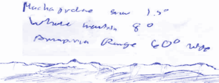
The mountains, it turns out, do turn purple just after sunset. I don’t know why I didn’t know that. There were more stairs, and my knees hurt, but the weight of the backpack was behind at the lodge, and as the stairway hugged the south face of the ridge, I would not catch sight of Machapuchare until the very top. So, I hobbled up, slowly. While I tottered, the other tourists decamped from the summit, and by the time I arrived the last of them, a tall, shaggy blond american with a book and a little nepali kid, were just walking away. I staggered to the bench on the platform on the northern edge of the ridge, looking out across the valley at one of the dozen tallest points on the planet. As only God and those with smartphones know whether the morning will be clear, I fished out a pen, and scribbled on the back of some printout I found in my pocket. The little dark triangle under the ‘r’ in Annapurna, just that triangle, is two kilometers high.

Comments»
No comments yet — be the first.